Strategic planning during and after hazardous events is strongly tied to the amount of information available to domain experts and decision makers. In the framework of SAFERS, the task - EO-based fire delineation and burned area for impact assessment (T3.6) is dedicated to the approaches and the devised solutions for rapid mapping and severity assessment utilizing satellite images as sources of data.
The conducted actions deal with the rapid damage assessment tools designed for the SAFERS project, namely a set of models and components to automate satellite mapping procedures and forecast evaluations that would require extensive manual labor in the first case, or extremely expensive simulations in the latter case. Given the results obtained within SAFERS, machine and deep learning solutions remain promising approaches for both scenarios.
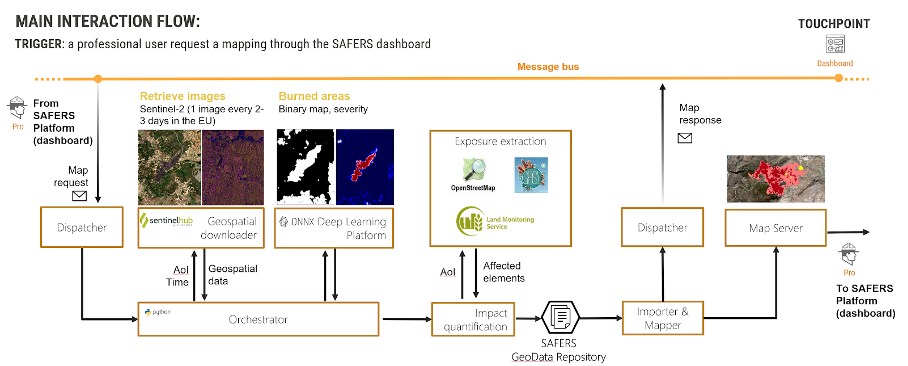
Figure 1- High-level architecture of the EO-based delineation service
Moreover, part of wildfire management is the long-term monitoring of post-wildfire habitat recovery. Earth observation is an important tool to support this because it allows to regularly observe the status of an area over time using a standard product. This is task 3.7 of the SAFERS project - EO-based post-wildfire habitat recovery monitoring. The aim of this task is to develop and also provide novel input into United Nations Sustainable Development Goals (SDG) relevant to the consequences and aftermath of wildfire disasters. Resilience is a key theme of this task and applicable to SDGs 11, 13 and 15.
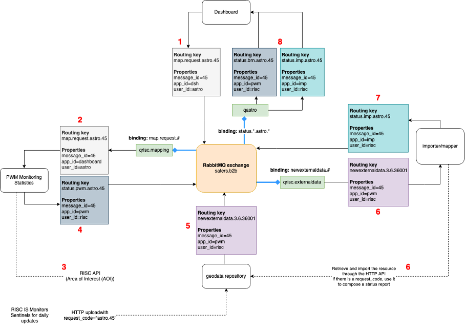
Figure 2- Post-wildfire habitat recovery monitoring IS message flow on the SAFERS bus
This blog article divides the discussion between these different tools, first describing the collected service requirements, service architecture and methodologies for information gathering, considering also their integration with the overall SAFERS architecture.
Concerning the satellite-based wildfire delineation service, Sentinel-2 satellite imagery has been exploited to train and validate burned areas delineation and severity estimation models. The approach is based on state-of-the-art segmentation networks, and it can generate binary masks or severity maps of a given area and time interval. An extensive experimental phase was carried out to optimize hyperparameters, leading to optimal performances in both the burned area mapping and severity estimation scenarios. The solution is deployed in a multi-module containerized architecture, whose only means of communication is represented by the SAFERS asynchronous message bus. In order to maintain a certain degree of isolation between components, the data flow is divided into data retrieval, model inference and request orchestration. These three phases are handled by different submodules, named Geospatial Downloader (GSD), Deep Learning Platform (DLP) and Orchestrator.
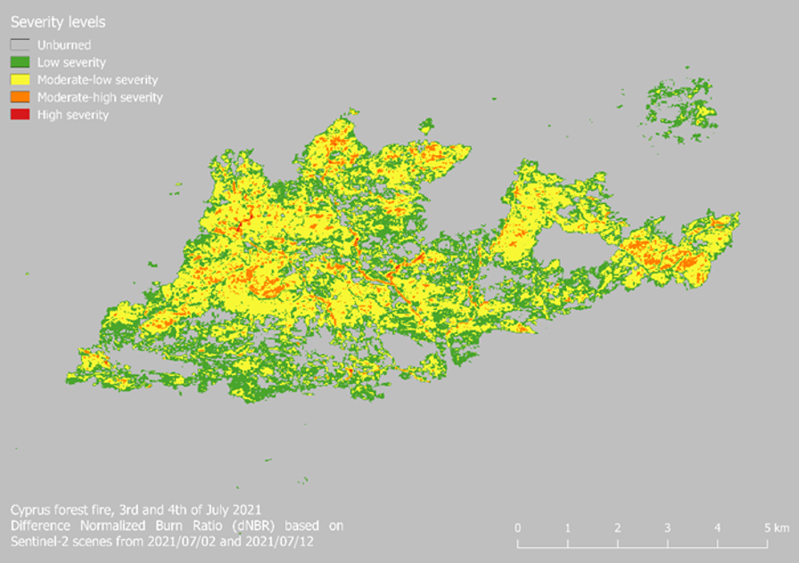 Figure 3- The differenced Normalised Burn Ratio (dNBR) computed from multi-temporal Sentinel-2 imagery acquired between 02 July – 12 July 2021
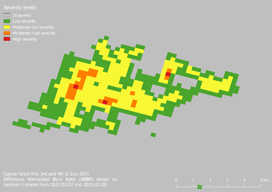
Figure 4- The dNBR presenting wildfire severity based on multi-temporal Sentinel-3 acquisitions between 02 July – 05 July 2021
These software tools are first introduced with respect to the overall project architecture, and later focusing on the individual characteristics and implementation details. The experiments focused on achieving high accuracy models for the delineation of burned regions. The best approach for severity estimation proved to be the multi-step pipeline approach, first roughly estimating the extents of the damage, followed by a finer damage prediction. The best fire models have been operationalized exploiting a modular deployment scheme, composed of several intercommunicating components. The final architecture presents several advantages: components are distributed and fault tolerant, avoiding single points of failure, isolated thanks to containerized deployments, and asynchronous thanks to internal brokers and the shared project-level message bus.
Considering instead the EO-based post-wildfire habitat recovery monitoring, at its core there will be three Copernicus satellite constellations: Sentinel-1 data will be processed to monitor post-wildfire ground movements and soil degradation. Sentinel-2 will monitor the recovery of plant species within the burned area. Sentinel-3 will provide fine temporal monitoring of the recovering vegetation and support the seasonal vegetation mapping based on Sentinel-2 imagery to improve vegetative habitat monitoring.
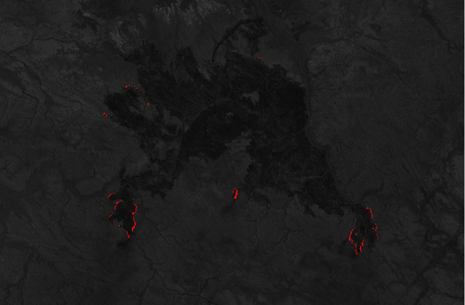
Figure 5- Example fire front result derived from applying the script to a S2 image (source: Sentinel-hub)

Figure 6- Burned area derived from NBR, based on Sentinel-3, 5th July 2021
SAFERS will develop European competencies in the monitoring and reporting of post-wildfire habitat recovery and is expected to create a service for multi-year reporting. A significant result of this task will be to support positive economic, social, and environmental links across the Wildland Urban Interface (WUI), help improve regional and national development planning, as well as strengthen efforts for the protection of natural heritage.