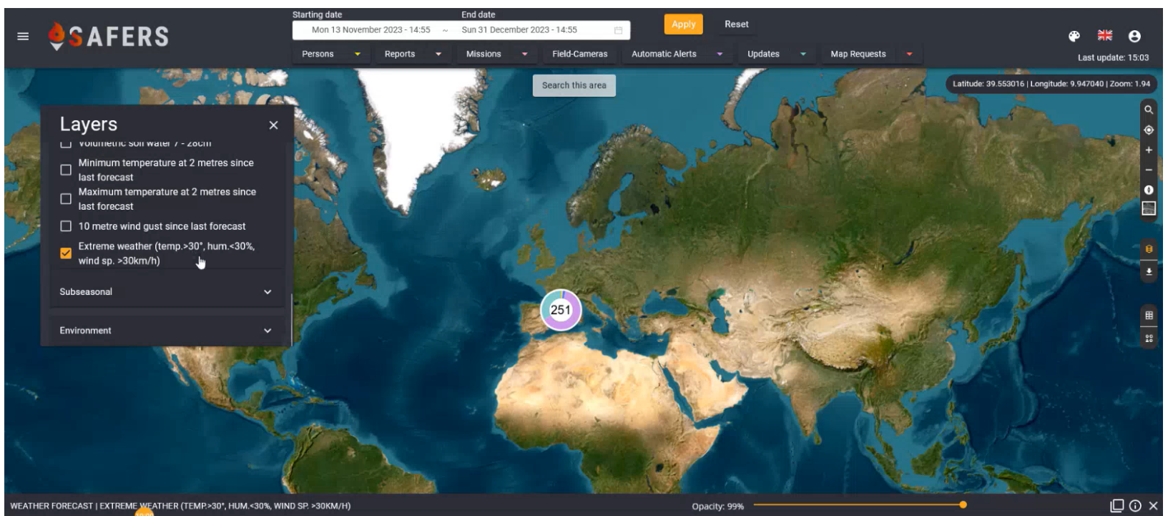
In this blog article, we present SAFERS Web-based dashboard for operational management and Decision Support. The Dashboard is one of the user-facing components of SAFERS. By providing a single interface for interacting with forest fire related data and information, the dashboard aims to improve emergency management efficiency of end-users when facing fire emergencies. Forest fires are a major threat to our planet, and climate change makes them more unpredictable and destructive. That is why we need new solutions to better manage forest fire emergencies, performing early detection, fast and effective response, and targeted restoration actions aimed at recovering the losses while reducing the impacts of future events. The SAFERS Dashboard is a web-based graphical interface that allows a user-friendly geospatial data visualisation in an easy-to-digest form for operational management and decision-making. Powered by the SAFERS Intelligent Services, the Dashboard receives and requests data from various sources, including earth observations from Copernicus, outputs from AI models for burned area delineation and fire propagation forecasting, imagery from cameras installed in forests, topographic data, weather forecasts, in-field data from mobile devices, and relevant social media information.
Using this tool is very simple. Just select a temporal range and use the map to navigate to your area of interest, you will be able to see any relevant data, including key weather variables (such as temperature, humidity, precipitation, wind, lightning activity or solar radiation) produced by different models: short-term deterministic forecasts, with lead times up to 3 days, up to sub-seasonal probabilistic forecasts, with lead times up to 45 days. The information can be seen as a map as well as in a temporal chart for a better understanding of the evolution of the selected variable at a selected location. The platform provides in situ cameras installed in strategic locations to early detect and monitor active fires that may trigger in highly risky environments. AI automatically analyses the images and promptly triggers an alert in case a smoke or a fire is detected.
A chatbot integrated within the Telegram messaging app allows first responders to update their location, operational status, and exchange real-time multimedia reports with control centers, in which decision-makers can generate geofenced messages and manage missions using the Dashboard. Also, citizens can use the chatbot to learn correct practices related to forest fire management and self-protection behaviours through useful tips and quizzes, receive communications from control centres, and share reports. For them, the experience is gamified to promote their engagement and to provide decision-makers with a measure of the reliability of their content, which is subject to peer reviews and final validation. Moreover, the Dashboard allows the on-demand request of model runs, enabling to quickly receive fire propagation simulations, burned area delineations and impact estimations, and vegetation recovery assessments. Also Social Media can be a source of information, and the Dashboard can display relevant data related to ongoing or past emergencies thanks to an advanced AI pipeline that processes the text as well as the medias attached to the social media posts on X (formerly known as Twitter). Thanks to the SAFERS Dashboard and Intelligent Services, decision-makers will have an easy, fast, and innovative forest fire emergency management system that can be easily integrated with local data and systems, enhancing existing capabilities.
The SAFERS service-oriented architecture
The SAFERS project aims to define a novel set of EO services and to develop new commercial products. In doing so, SAFERS developed and built a solution that could be deployed everywhere and could be also replicated everywhere. SAFERS is based on a complex system architecture composed of a data lake and modules/ blocks that can be combined to provide a wide set of functionalities. In fact, following the experience from previous projects and preliminary end-user suggestions, SAFERS has been conceived as a modular system, able to provide different types of services that can meet a multitude of customer needs. The overall SAFERS architecture is reported in the figure hereafter.
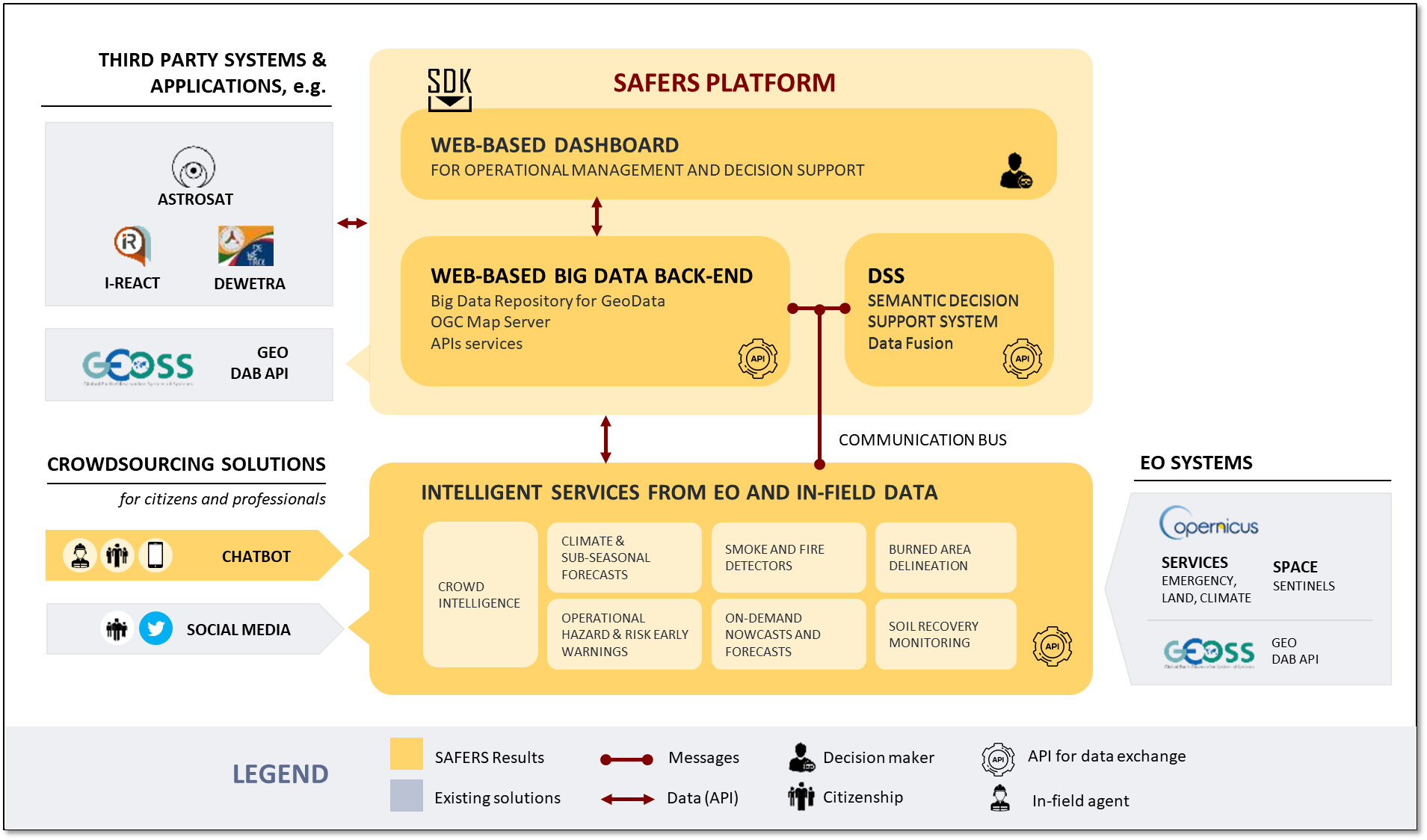
As showed, SAFERS is composed of two main macro-components: SAFERS platform and SAFERS intelligent services (ISs). The SAFERS platform is based on three components:
- A web-based dashboard, through which decision-makers will be able to effectively visualize all generated data and map products supplied by the SAFERS intelligent services, allowing to provide a single source for all relevant information in a timely manner, in order to adequately support the decision-making process. The SAFERS web-based dashboard will allow various functionalities: i/Integrate the data coming from the SAFERS ISs; ii/ Visualise all data, presenting the combined data in an easy to digest form; iii/ Provide actionable insights, allowing to trigger alerts and highlight emerging risks to help decision-making; iv/ Continuous monitoring, providing the ability to track and assess the effects of actions taken.
- A Geodata Repository & Importer and Mapper: it includes a Big Data Repository for any kind of data (Data Lake), where INSPIRE-compliant data will be stored; an importer and mapper that will enable to create map layers and deliver them through Open Geospatial Consortium standards; and Application Programming Interfaces-APIs services that will allow for data sharing and management.
The SAFERS service-oriented architecture also enables a data-driven exploitation model, where the data generated within the SAFERS ecosystem could also be exploited in other existing tools and solutions.
The SAFERS intelligent services
A set of modules able to run independently provide the so-called “SAFERS intelligent services (IS)”. Thanks to the use of interoperability interfaces and standard communication protocols, the outputs of all these intelligence services can be easily integrated into other platforms or into other European solutions. These are briefly described hereafter:
- Semantic Decision Support System extracts useful insights and knowledge to facilitate advanced decision-making and support human operators and authorities to map their operational procedures. It allows assisting in critical phases of firefighting management as it provides recommendations; performs data analysis enabling to execute actions (e.g., communicate advice); and as well recommends the solutions and best practices coming from the integration of multiple data. In particular, the DSS allows communicating advice to citizens (e.g., not to abandon litter in the woods) in the specific area and where the FWI variable is high; provides recommendations to decision-makers regarding the FWI, Fine Fuel Moisture, Duff Moisture, and Drought anomalies in potential areas; and assist in the prescribed burning process by providing the visualization of the regions that this activity can be conducted and which times.
- Social media analysis: is a 24/7 monitoring service. It utilizes an AI-based module to gather information about wildfire events from social media platforms like Twitter, enabling event detection and tracking as well as real-time content classification for emergency management scenarios. The main goal of this service is to extract informative content related to forest fire events, select and classify multimedia information (e.g., text, images), detect events, and extract impacts in the affected area in terms of affected people and infrastructure.The reason for selecting Twitter as main platform is its provision of an open API for accessing data. It should be noted that the availability and accessibility of data on Twitter are subject to the platform's policies, which may undergo changes over time. However, it is worth mentioning that all the data collected through the SAFERS service are intended to be sourced from public and openly available information.
- Chatbot for citizens and volunteers: The SAFERS Bot is a Telegram bot developed for citizens, professionals and volunteers to help decision makers in the prevention, monitoring and management activities for forest fires. The chatbot application aims to provide a bidirectional communication between the control room and in-field professionals and volunteers, as well as engage citizens as active users able to collect useful real-time information. It allows to both deliver and retrieve multimedia geolocated contents from smartphones. It can also act as a warning system in potentially affected areas, as it enables the broadcasting of important communications through push notification. Furthermore, it facilitates the coordination of both people and tasks. Indeed, it allows real-time sharing of their location and current activity, and it enables organized task management with the mission functionality, assigning specific tasks to individuals or teams and tracking their progress. For citizens, a gamification strategy has been designed and implemented to promote users engagement, to improve people’s awareness about the correct behaviours to hold in case of emergency, and to encourage them in becoming proactive agents in the information collection process.
- Sub-seasonal weather forecast provides forecasted occurrence risk of relevant, high-impact weather variables and indices for wild/forest fires in time scales of days up to six weeks. In detail, the SAFERS intelligence service delivers information and data related to:
- Short-range weather observations (up to 3 days): This service provides hourly high-resolution forecast of relevant weather parameters for the upcoming 72 hours. The forecast is updated twice a day and allow its visualization over map, with different timeseries, zoom-ins, pan, overlays of different weather parameters with other data. These indices give information for awareness and early warning potential risk;
- Medium-range weather forecast and Fire Weather Indices (up to 15 days): This service provides twice a day ensemble mean and 80% prediction interval of the ensemble forecast of relevant weather variables as well as Fire Weather Index, moisture codes and their anomalies using 40-year historical mean values. It allows the visualization over map, timeseries, zoom, pan, overlays of different weather parameters with other data. These indices give information for awareness and early warning potential risk.
- Sub-seasonal forecast (up to 42 days): This service provides probabilistic forecasts of relevant weather variables up to 42 days. The product includes ensemble mean and 80% prediction interval and is updated twice per week. It allows the visualization over map, timeseries, zoom, pan, overlays of different weather parameters with other data. These indices can be used in response-phase of forest fires.
- Operational early-warnings aims to augment the current operational wildfire early warning services with automated processes and local data fusion and model outputs. It is integrating EFFIS data, lightning forecasts, and user-provided local data. The service will allow automatic triggering of local services based on high-resolution Earth Observation imagery. Many emergency operators have access to certain levels of information, as already available. This SAFERS service aims to improve the existent information to make operations safer and better, by reducing the effects of forest fires. In particular, it combines various sets of information from weather forecast; wildfire monitoring; wildfire risk models; automatic EO mapping - especially from Copernicus – integrating, as well, local user inputs.
- Smoke and fire detection system (smoCAM). Based on artificial intelligence, it analyses images aiming to detect the presence of smoke and fire. It provides a video analytics solution that works in the visible spectrum and exploits common surveillance cameras to early detect smoke plumes in outdoor, thus reinforcing prevention activities even when thermal cameras may fail. In detail, it enables the detection of smoke and fire from non-dedicated in-situ video surveillance cameras, complementing the already existing proprietary WV solutions. The service acquires images from the pilot sites cameras and analyses them in real time to provide a prompt response on the presence of possible wildfires.
- Fire propagation model can be used to predict the spread and the potential impacts of an active fire, based on Earth Observation data, in order to support the decisions-making during forest fire emergencies. In particular, this service provides on-demand nowcast to be used to predict fire behaviour, to define the strategy of fire attack, to anticipate emergency conditions, to adequate planning of evacuation and to simulate fire attack strategies.
- EO-based fire delineation model establishes an on-demand service able to delineate and estimate the severity of a burned area using Copernicus Sentinel-2 imagery, when available, and advanced artificial intelligence algorithms. In detail, an AI module is able to delineate burned area boundaries and the relative severity based on Sentinel-2. Moreover, the service is also able to produce maps with fire fronts and assessment of potential impact of the fire.
- EO-based post-wildfire monitoring provides a monitoring service, that will use imagery obtained from Copernicus Sentinel satellites and, in particular, Sentinel-2 for vegetation. This service aims to provide past and up-to-date vegetation maps to sustainably restore and monitor planned burned area restoration for automated reporting. This service offers continuous monitoring, provide context to the development of post-wildfire recovery especially for Wildland-Urban Interface (WUI) planning; automate the monitoring of vegetation re-growth based on climate change resilience programs; and provide the quantification of forest fuel[1]
Thanks to the use of interoperability interfaces and standard communication protocols, the outputs of all of these intelligence services could be also integrated into other systems or into other European solutions.
To learn more about SAFERS Platform Core Components: Link