This blog article is dedicated to the third demonstration and training activities performed on the 10th of October 2023 in El Perelló (Catalonia, Spain) to test and evaluate the SAFERS Intelligent Services (ISs) that are integrated into the dashboard and the chatbot. The execution of the third demo served to test the first release of the β2 version of the SAFERS integrated system. The event brought together the members of the SAFERS Consortium with local stakeholders invited (first responders, emergency authorities and citizens). The main objective of the SAFERS demos is to assess the capabilities of the tested services to assist decision-making processes across all the phases of the wildfire risk management cycle (i.e., prevention & preparedness, detection & response, adaptation & restoration), including the engagement with citizens.
Organisation and site description
Pau Costa Foundation organised the SAFERS demonstration in Spain with the collaboration of Forest Defense Group (ADF) from El Perelló, a volunteer first responder organisation that supported in the performance of the operations, and Enervent SA company, the owner of the venue (facilities of the windmill farm) where the pilot took place.
The pilot site is located between the Areas of Natural Interest (PEIN) “Serra de Cardó” and “Tossal de Montagut”. The demonstration pilot was inspired by El Perelló fire, from June 2019 that burned across 250 ha, 95% of forestland and 5% of agricultural land. The simulated fire had burned public lands which are owned by the Catalan Government. Thus, the management of the area corresponds to the Forest section within the Department of Climate Action, Food and Rural Agenda. Agriculture and livestock farming have been the main economic drivers that have shaped the pilot site. These activities are deterministic given their socio-economic and environmental impacts on the landscape.
Training sessions
Considering the experience in the previous demos, where the lack of experience from the external participants regarding SAFERS platform slowed down flow of the exercises, preparatory trainings were organised in advance. Hence, the trainings, were organised to guarantee sufficient understanding of, and familiarity with, the system by the users prior to the pilot demonstration. It is worth mentioning that prior to these trainings bilateral meetings took place with all SAFERS technical provider in order to become proficient with the use of the ISs accordingly technical providers of the project to be able to provide then the training to the demo participants.
Two preparatory trainings were organised, each targeting a different organisation with an active role during the development of the demo. The first training took place in September (18 – 19) 2023 in Brunete (Madrid) on the premisses of Vigiles and targeted the students from the Vigiles Training Academy of Civil Protection. The aim was to introduce the basic usage of the chatbot for citizens so that they could remotely participate in the third demo by sending reports including pictures, voice messages, descriptions, and videos of a fictional fire event in which they would be involved. The training was split into two sessions: the first one took place on Sep 18th in the evening, with students from the afternoon shift; and the second on Sep 19th in the morning, with the students from the morning shift. Altogether, the training was given to 90 students (30 from the afternoon shift and 60 from the morning shift), however they split in groups of 3-4 people to better handle the training session. Each group was given credentials to log into the chatbot and instructions about their expected participation during the day of the demo.
The second training took place on September 23rd 2023 on the headquarters of the ADF from El Perelló and in the field. It aimed at introducing the storyline that had been prepared to perform the demo exercise in a step-by-step process to ADF members, l’Espluga de Francolí, and La Morera de Montsant, and to provide them with basic notions on the use of the Intelligent Services integrated into the dashboard as well as the Chatbot to achieve appropriate performance during the execution of the demo exercise. The first part of the training took place at the headquarters of the local ADF, and served to present and operate the dashboard and the different ISs that are integrated as well as the Chatbot, allowing them to interact with the tools, get familiarised, and sort out any questions. The second part of the training took place in the field, close to the location where the SAFERS detection camera is installed, and served to decide on the best spot to launch the smoke bombs, and perform a test to test the camera detection IS. The training was given to 7 ADF members who held the role of CCC chief operators and on-field units during the execution of the demo. They were given nominal credentials to log into the dashboard and/or the chatbot, and instructions about their expected participation during the day of the demo.
The third project demo was attended by a total of 85 people: 26 from the SAFERS Consortium and 59 from a total 17 organisations from Catalonia, most of them involved in wildfire risk management operations. In addition to them, 90 students from the Vigiles Training Academy of Civil Protection in Madrid participated remotely. The event recorded the participation of the following organisations and relevant projects.

The execution of the demonstration
A wildfire risk scenario storyline - (based on the historical fire in El Perelló in 2019) - was designed before the event. To facilitate the comprehension of the storyline deployed during the demo exercise, two screens were set up in the room.

It brought together managerial and operational procedures across all the phases of the DRM cycle: Prevention and Preparedness, Detection and Response, and Restoration and Adaptation. Hence, the storyline was structured in 11 sequential scenes, that started with the synoptic risk situation, were followed by the start of the fire and the response operations performed by the emergency organisations and finalised with the post-fire monitoring assessment in the aftermath of the event. Every scene involved the use of at least one of the SAFERS ISs, demonstrating how they can assist in decision making processes related to wildfire risk management scenarios.
1. Prevention and Preparedness phase
The concerned scenes came before the actual fire event occurs. A weather scenario similar to the real one that preceded El Perelló fire in 2019 was related. The fire chief at the CCC want to check weather conditions that can be conducive to potential wildfire risk scenario and thus improve the situational awareness for the planning of resources.
The weather forecast service was used to consult the medium and long-term (i.e., sub-seasonal) weather forecast maps.The meteo variables consulted were: medium rang (temperature at 2m height, relative humidity, wind (speed and direction), averaged total lightning, extreme weather); subseasonal (total precipitation); environment (Fire Weather Index (FWI), drought code, drought code standardized anomaly). As a result, attendees were able to see the different maps generated for each variable, the interaction of variables, and the different options to customize the result.
In addition to this, a new prescribed burning module that is under development was tested within the scope of this scene.
The semantic reasoning service automatically triggers alerts messages that the user consults and discusses for different areas of Catalonia. The Fire Weather Index (FWI) produced at European level was used as a reference to create, adapt, and disseminate alert messages addressed to the population and to first responders separately, according to the level of risk determined in their territory.
2. Detection and Response
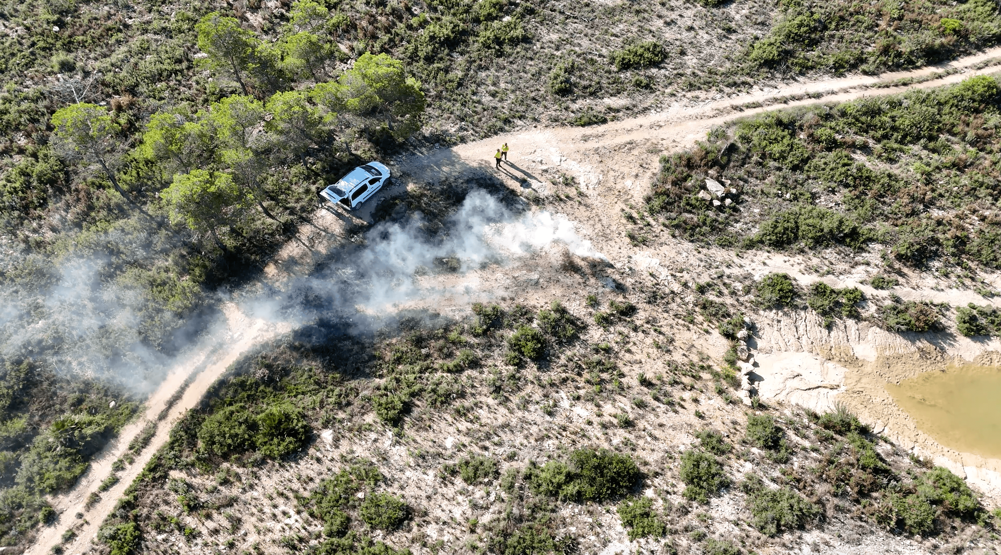
This phase tested the detection camera that was installed in the forest area (burned in 2019) A team of ADF members went to the field carrying smoke bombs to artificially generate a smoke column that could be detected by the installed camera. The smoke bombs were launched in an area that had been previously selected within the range of visibility of the camera. The software detected the smoke plume and automatically triggered a fire alert in the dashboard. The team in the CCC validated the alert through the direct visualisation of the images taken by the camera.
In addition, the Dashboard and Chatbot messaging services were used to perform bilateral communications between CCC chief operators and first responders regarding the dispatch and monitoring of first responders going to the field. The on-demand fire simulator was also used to predict the potential fire spread and behaviour and assess their potential impacts. This first simulation is run as a free simulation (i.e., with no manoeuvres or any type of boundary conditions considered in the simulation) in order to know the maximum fire extent, given the ignition focus that had been detected by the camera. This provides relevant information for the first attack and anticipate the possible impact on other critical points (infrastructures, urban areas...).
The SAFERS dashboard was additionally used to create a mission that were taken in charge by the first responders in the field. First responders in the field take up the mission and report on the state of the operation to the CCC, thus creating a communication flow to monitor the evolution of the fire and the exchange of information between field-CCC.
During the same phase, the weather forecast service was used to check the short-term weather forecast maps. The user navigates across thew dashboard consulting various weather parameters.
On the other hand, the crowdsourcing service is used to search and mass filter social media posts on Twitter related to a fire event. For the demo, the Santa Coloma de Queralt wildfire from 2021 was chosen, rather than El Perelló fire from 2019, due to the lack of information retrieved from the latter during the dry-run tests conducted in preparation for the demo.
To obtain information about the potential fire spread and behaviour, the on-demand fire simulator was employed in this phase. To that end, a second simulation was run, this time including the executed and planned firebreaks (suppression manoeuvres). This allows to have an estimate of the fire evolution and discuss the operational procedures undertaken in response.

3. Restoration and Adaptation
In the aftermath of the event, the fire footprint remains over time for months or even years. Knowing the final perimeter of the affected area allows the understanding and reconstruction of the movements of the fire. To investigate the fire impact, the fire delineation and burned area mapping service was used to automatically get the contour of the area affected by fire, giving way to further analysis related to fire impacts and restoration measures to take in response. The participants were invited to test the fire tool with other fires they were familiar with. The input data related to two recent fire from Catalonia, El Pont de Vilomara in 2022 and Roses in 2022, were also provided for testing. Attendees were able to see how the final perimeter of the burned areas can be determined automatically and accurately, and could also download the layers to further edit and analyse them on their local systems through a GIS.
Last but not least, the post-fire vegetation recovery monitoring service was used to evaluate the evolution of the vegetation overtime during a period of 1 year after the fire event.
The user had to input the date of the fire and draw a polygon around the area where the event fell inside. The output obtained consisted of two distinct maps, one used to assess the vegetation recovery (using the NDVI index), and another one used to assess the soil recovery (using the dNBR index). The outputs allowed to explore the recovery processes overtime through quarterly-based timeseries for a total period of 1 year. Similar to the service used in scene 10, participants were invited to test the tool with other fires they were familiarised with.
Feedback
The demo also included a feedback session at the end to collect end-user feedback for evaluating the effectiveness and usability of the SAFERS ISs. The feedback session consisted of two distinct parts: first, an open discussion was animated by PCF in local language to receive direct comments and suggestions from the local stakeholders; second, the local stakeholders were asked to respond to an online questionnaire through QR code that was displayed on the main screen.

The demo event was characterized by a successful media coverage. Three television media attended the event to film the development of the exercise, both at the CCC and on the field, and record some interviews with some of the actors involved. The SAFERS demo was broadcasted in the news TV channels covering the whole Catalonia, the province of Tarragona and the Ebro region, respectively. The videos are available online:
- TV3 – Televisió de Catalunya (broadcasted for the entire Catalonia): https://www.ccma.cat/tv3/alacarta/telenoticies-comarques/safers-el-prototip-europeu-per-preveure-identificar-i-extingir-incendis-forestals/video/6244458/.
- TAC12 (broadcasted for the province of Tarragona): https://www.tac12.tv/programes/connecta-10comarques/item/30703-connecta-10comarques-capitol-484. (SAFERS demo from minute 15:00)
- Canal TE – Canal Terres de l'Ebre (broadcasted for the Ebro region): https://www.youtube.com/watch?v=zl9toXn8Qlw.
Based on the lessons learned from the execution of the previous demos, the third demo switched the format to become more operationally oriented, endeavouring to connect the overall performance with realistic wildfire management periods, thereby allowing the audience to understand how the SAFERS tools can be used across different management operations.
This event allowed to gather information on the reliability and usefulness of the SAFERS integrated solution by emulating a wildfire risk scenario that combines operations both at the Command-and-Control Centre (CCC) and on-the-field.
The β2 version of SAFERS Chatbot tested in the field by professionals and volunteers demonstrates relevant improvements. One of the significant problems documented in the previous pilots, the report creation, has been overcome by exploiting the conversational clues offered by Telegram, which provided a better experience. The same positive result was observed with citizens, who facilitated interaction with the bot and sent multimedia. The Spanish citizens reflected on the utility and applicability of the bot, acknowledging the great potential of this service to positively engage people in environmental monitoring and safers behaviours, especially in small towns or heterogeneous clusters of subjects, including private companies.
This pilot was the third out of the four project demos. The first took place in Corsica (France), in October 2022, the second in Piedmont (Italy) in February 2023, whereas the fourth and last one was held in Thessaloniki (Greece), in December 2023.